Thursday, April 12, 2012

Tahiti's Climate

Tahiti is a warm tropical island located in the subtropical latitudinal belt. The warm temperatures are due to Tahiti residing not far from the equator at about 17 degrees south. The diurnal (daily) temperature only varies between 78 and 85 degrees Fahrenheit throughout the year.

map of tahiti, tahiti maps, detailed map of tahiti
http://www.worldatlas.com/webimage/countrys/oceania/tahiti.htm

Above displays Tahiti's latitudinal distance from the equator.

Annual temperature range above shows very little variation.
 Tahiti’s seasons change with fluctuations in the trade winds. Trade winds are caused by warm air masses rising in equatorial regions. The winds are deflected to the left (Southern Hemisphere) by the earth’s rotation known as the Coriolis effect. The winds travel from subtropical high pressure zones to the intertropical convergence zone (ITCZ) located at the equator.
http://science.kennesaw.edu/~jdirnber/oceanography/LecuturesOceanogr/LecCurrents/LecCurrents.html

This displays the creation of clouds. The trade winds move from a high pressure zone to
converge with a low pressure zone. The formation begins with stratus
clouds and ends with cumulonimbus (rain producing) clouds.

The island has two main seasons, a dry and a wet season. The dry season takes place from April to October during the Southern hemisphere’s winter. During this time, the average daily temperature is lowered due to the southeast trade winds. The rainy season is November through March which brings much of the precipitation from the Northeast humid winds.


The dry and wet seasons are apparent by the variation of rainfall.
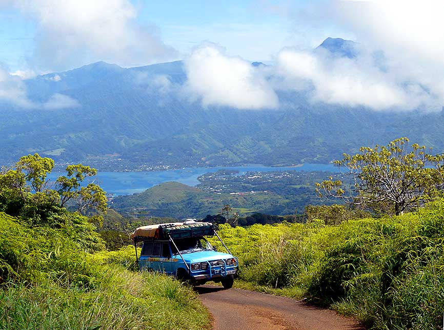
http://mtp.mjmahoney.net/www/missions/pem/tahiti_pg.htm

The capital city of Papeete displaying the orographic lifting.

The topography of the island has a major influence on the spatial distribution of precipitation. Trade winds are full of moisture but do not usually produce rain unless forced to rise. Tahiti's peaks cause the air mass to rise through orographic lifting. As the air mass tries to climb over the volcanic peaks, it cools as it reaches its dew point. When the dew point is met, the clouds condense and release rain.
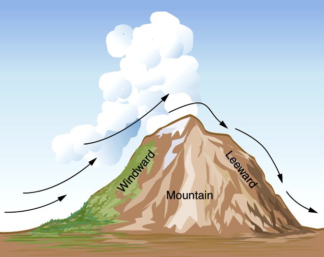
http://www.sci.uidaho.edu/scripter/geog100/lect/05-atmos-water-wx/05-part-7-atmos-lifting-fronts/ch5-part-7a-atmos-liftin.htm

Above shows air cooling adiabatically (by expansion) cooling of air causing precipitation. Rain falls mainly on the windward (east coast of Tahiti) before it makes it to the leeward side (west coast of Tahiti).
The majority of Tahiti’s precipitation falls on the east coast. The topography and direction of the wind causes less precipitation to make it to the west coast creating a rain shadow (shown above).  Annual rainfall on the east coast is about 138 inches compared to 59 inches on the west coast. All of these components come together to create the beautiful climate of Tahiti.


References:
Wotling, G., Bouvier, C., Danloux, J., & Fritsch, J. (2000). Regionalization of extreme precipitation distribution using the principal components of the topographical environment. Journal of Hydrology, 23(1-4), 86-101. Retrieved from http://0www.sciencedirect.com.skyline.ucdenver.edu/science/
article/pii/S0022169400002328

Carpenter, K. E. (n.d.). An introduction to the oceanography, geology, biogeography and fisheries of the tropical and subtropical western and central pacific. 1-17. Retrieved from http://www.fisheries.go.th/if-suratthani/web2/images/download/v103.pdf

Allen, C. (n.d.). Geog 1202: Introduction to physical geography. Retrieved from http://clasfaculty.ucdenver.edu/callen/1202/

Wednesday, March 7, 2012

Erosion of Tahiti


As I stated in my previous post, Tahiti has quite steep terrain which is not typical of a shield volcano. What is typical, however, is the radial drainage pattern on the island (seen below).

 Radial drainage basins of Tahiti are apparent by the steep ridgeline
radiating out from the center of the main island.
(http://www.sciencephoto.com/media/97528/enlarge)
Tahiti receives 79 to 315 inches of rainfall annually attributing to constant erosion. This is evident by the islands deeply dissected gullies through which the rivers flow. The gullies started out as rills. The rills grew from the constant flow of precipitation that exceeded infiltration capacity or overland flow. Rainwater enters the drainage basins and into the rivers radiating from the center of the island.


Papenoo river carrying rainwater from the center of
volcano.
(http://svocelot.com/Landfalls/French_Polynesia/tahiti.htm)
The lush vegetation shown above displays how Tahiti has some
protection from erosion.
(http://www.tahitiexperience.com/Infopages/Society/TahitiFile.htm)


The island has steep slopes that aid the rivers in the alluvial transport of material. Erosion on some slopes are hindered by the vegetation from the lush tropical forests.

The capital city of Papeete continues to clear vegitation for the growth of the city.
(http://www.tahitisouvenirs.com/QsnEN.html)

Greater erosion occurs in the towns on the West side of Tahiti-Nui (above) and the croplands of the Taravao plateau (below). There is less vegetation to prevent erosion because of agriculture and construction efforts.

The plateau of Taravao is subject to erosion from agriculture. Also there are examples
of oxisol soils in the bottom left corner of the picture.
(http://www.daodao.com/Tourism-g309679-Tahiti_Society_Islands-Vacations.html)
High temperatures and high precipitation allow for the process of laterization. This process creates dark red soils composed of aluminum and iron. Laterization breaks down all other components of the soil like silica resulting in oxisol soil. The oxisols are very weak in nutrients for the vegetation (examples above and below). Instead the vegetation must quickly absorb nutrients through exposed roots, vines and large leaves.

Beautiful image of the lush vegitation as well as the oxisol soil of the road.
(http://www.weltrekordreise.ch/bilder%20pf/030-P1090560.jpg)
Tahiti also has histosols organic soils. Histosols are saturated with water most of the time and are dark in color. Histosols have more organic matter than oxisols but are not abundant on Tahiti. They can be found near sources of water (see below).

The waterfall has histosol soil on either side. Easy to find by
the black color.
(http://svocelot.com/Landfalls/French_Polynesia/tahiti.htm)
Tahiti has such a beautiful lanscape because of the thousands of years of erosion from rainfall. This has created an amazing land to explore and observe the beauty of nature.


References:
Ye, F., Sichoix, L., Barriot, P., & Dumas, P. (2010). Modeling the erosion of sheild volcanos: The tahiti case. Retrieved from http://www.interpraevent.at/palm-cms/upload_files/Publikationen/Tagungs
beitraege/2010__690.pdf


Allen, C. (n.d.). Geog 1202: Introduction to physical geography. Retrieved from http://clasfaculty.ucdenver.edu/callen/1202/

Saturday, February 11, 2012

Volcanic Landforms of Tahiti Nui


 The largest island of French Polynesia, Tahiti, is filled with many spectacular features. Once you look past the crystal clear waters and lush rain forests, you can see the beauty of the geography.

Tahiti Nui (on the right) and Tahiti Iti (on the left)  
Image borrowed from: http://www.welt-atlas.de/map_of_tahiti_3-190


Tahiti is comprised of two shield volcanos, Tahiti Nui and Tahiti Iti. They were both created by the same hot spot, magma rising from the mantle, under the Pacific plate. They are no longer active because the Pacific plate has moved west. Tahiti Nui is by far the most fascinating of the two shield volcanoes. The topography of the island is quite steep and does not show the gradual ascent for a normal shield volcano. The steepness is attributed to the many years of erosion from intense rainfall. 

Summit of Mount Orohena
Image borrowed from: http://travel.webshots.com/photo/1042692240012119764WpzSMl

The highest point is Mount Orohena (7,353 feet) which was the center of volcanic activity on the island. Common for shield volcanos, there was also lava flow in other places on the island. Dikes, magma flowing through vertical fissures, aided in carrying lava out from the center of the volcano. The erosion of the island lets us observe the dikes protruding the landscape. These intrusive volcanic land forms can be easily recognized by their steep linear structure.

Example of Dike on Tahiti Nui
Image borrowed from: http://photos.igougo.com/pictures-photos-p370657-Tahitian_Mountains.html

 In the northeastern section of Tahiti Nui you can see lava tubes. These lava tubes are the remnants of lava that cooled on the outer edges while liquid lava still flowed through the inside. The tubes are now a great location for tourist explorations. 

Lava Tube

Around the periphery of the island there are pahoehoe accumulations, smooth "ropey" basalt lava flows, that merge with the black sandy beaches. The black sand comes from the break down of volcanic rock and gets its color from the mafic composition of the basalt lava. Basalt lava is dark in color because of magnesium and iron in the rock.

Black Sand Beach on Tahiti Nui 
Image borrowed from: http://www.flickr.com/photos/kalevkevad/3336817775/ 


References:
Hildenbrand, A., Gillot, P., & Le Roy, I. (2004). Volcano-tectonic and geochemical evolution of an oceanic intra-plate volcano: Tahiti nui (french polynesia).          Earth and Planetary Science Letters,217(3-4), 349-365. Retrieved from http://0-www.sciencedirect.com.skyline.ucdenver.edu/science/article/pii/ S0012821X03005995

Allen, C. (n.d.). Geog 1202: Introduction to physical geography. Retrieved from http://clasfaculty.ucdenver.edu/callen/1202/

Saturday, January 21, 2012

Introduction


Hi everybody! My name is Siobhan Shaw. 
The location I have chosen is Tahiti which is part of French Polynesia. 


I chose Tahiti because it is an island I have always wanted to visit. I studied the island for my French class a few years ago. I instantly thought of Tahiti when choosing a place to study from a physical geography stand point. Apart from the beauty of this tropical island, the topography is quite interesting. Tahiti is made up of sandy beaches as well as tall mountains with lush jungles. I believe the variety on this island will help me to utilize information I will learn during the course of this class. 


Image from: http://www.vacation-best.com/tahiti-island/tahiti-island/